
Follow medieval pilgrims, floating trains, and all manner of British royalty on this trip across the Firth of Forth. You’ll start at South Queensferry, taking in some of the history that the crossing has to offer, before crossing the Forth Road Bridge to reach the village of North Queensferry.
Background
The name “Queensferry” comes from “the Queen’s Ferry“. The Queen in question was St Margaret (1045-1093), the wife of King Malcolm Canmore and the mother of three Kings of Scotland and one Queen of England. Margaret was a devout and pious Christian, and her work included the establishment of a permanent ferry across the Firth of Forth to allow pilgrims to travel north to the Abbeys at Dunfermline and St Andrews. The two villages of South and North Queensferry grew around the ferries, providing services for the pilgrims and other travellers.
The crossing at Queensferry grew over time, and by the 1790s it had become the busiest in Scotland. Substantial harbours were built to replace the ancient launching points, and ferries continued across the “Queensferry Passage” until 1964, when the opening of the Forth Road Bridge made the ferries redundant and put an end to this historic route.
Today the only ferries at South Queensferry take visitors out to the nearby islands. The landscape is dominated by the three bridges that now span the Forth, making it possible to drive or take the train to make the crossing in a matter of minutes.
This route takes in some of the history of the crossing as you journey from South Queensferry to North Queensferry via the Forth Road Bridge.

The Route
Distance: 6.5km (4 miles)
Start: Dalmeny Station, South Queensferry (NT 13899 77862)
Finish: North Queensferry Station, North Queensferry (NT 13155 80815)
Terrain: Level pavement for most of the route. Rough terrain and 120 steps between Dalmeny Station and Hawes Pier, and steps descending from the Forth Road Bridge.
Access: Dalmeny and North Queensferry stations are both on the Fife Circular line, with regular trains to and from Edinburgh. Bus 43 from Edinburgh stops at Dalmeny Station. Parking is available at Dalmeny station.
From Dalmeny station (NT 13899 77862), join a rough path behind a bus stop that runs through the trees between the railway and Ashburnham Loan. A footbridge crosses over the former Ratho to Queensferry railway and, after a short distance, a rather daunting 120 steps that lead down to a road. At the road, turn left to arrive on the seafront at Hawes Pier (NT 13698 78377). The pier is a popular launching point for tourist cruises on the Forth, and is also home to the local lifeboat station. On your left is the Hawes Inn, a former coaching inn that features in Robert Louis Stevenson’s novel Kidnapped, while on your right is the impressive sight of the Forth Bridge.
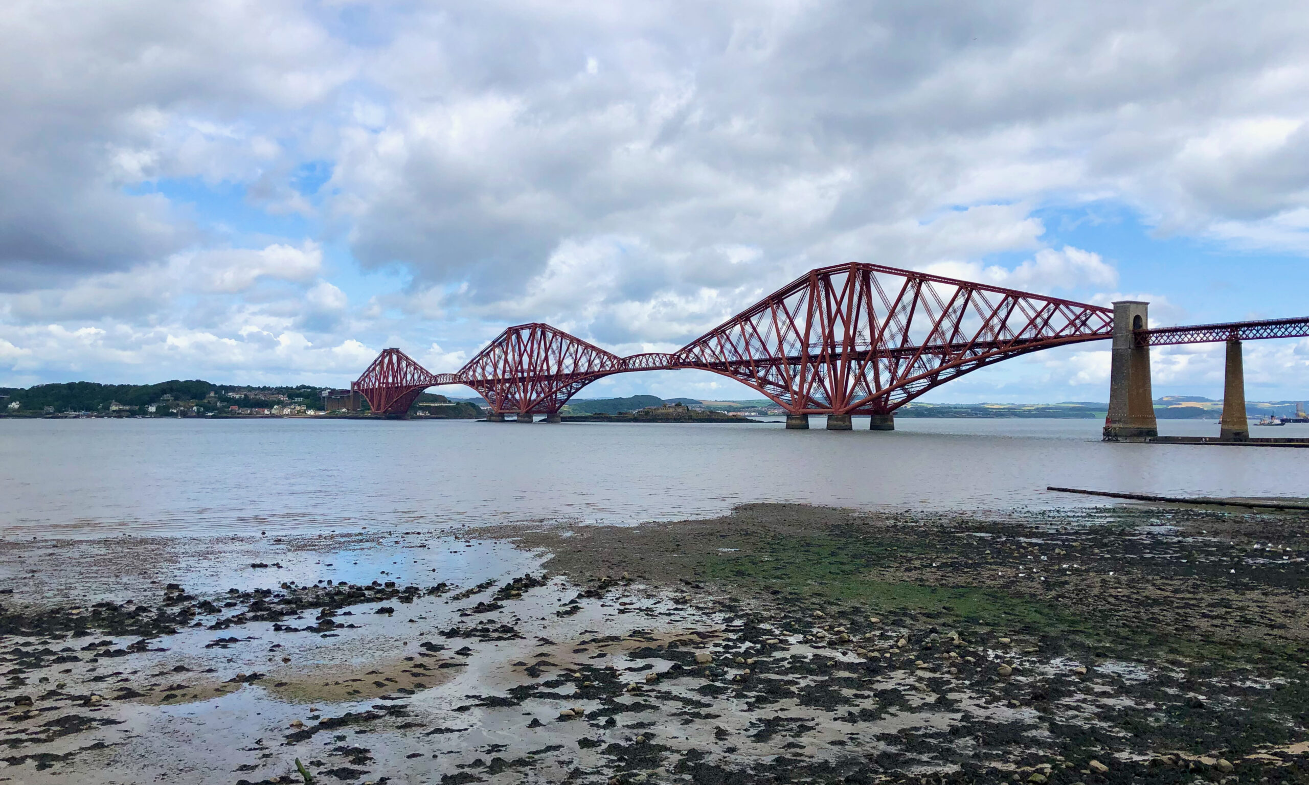
Measuring 2467 metres long and 110 metres high, the Forth Bridge is a marvel of Victorian engineering. It took over 4,000 workers to build the bridge using 53,000 tonnes of steel – and with the loss of at least 57 lives. The bridge is a UNESCO World Heritage Site and is widely considered to be a symbol of Scotland – its distinctive red paint gave rise to the expression “painting the Forth Bridge”, meaning a never-ending task.
With the Forth Bridge behind you, continue along the seafront to reach Queensferry’s quaint, narrow high street. There are many pretty buildings on this cobbled street, and the town’s registry office is a popular location for weddings.

Did you know: Before the construction of the Forth Bridge, travellers could take the train along the former railway line to Port Edgar where the world’s first “railway ferry” was in operation. Carriages were loaded onto boats which carried them across the Forth to join the railway to Dunfermline at North Queensferry.
After passing the Tollbooth and it’s distinctive clocktower, bear right onto Hoptoun Road until you reach a church on your right. This is the Priory Church of St Mary of Mount Carmel (NT 12869 78432). A friary was founded here in 1330, perhaps due to its position on the pilgrimage route, and the current church was built in the mid-15th Century. Following renovations in the 1890s, it is Britain’s only medieval Carmelite church that is still in use.

Past the church, turn right onto Rose Lane and cross the small car park. You’re now standing at an area known as The Binks (NT 12865 78500). While there were many ferries that crossed the Forth from Queensferry, custom has it that this natural rocky launching point was the site of St Margaret’s ferry.

While St Margaret might be the Queen most associated with Queensferry, she isn’t the only monarch to have made the crossing. Margaret’s descendant, Alexander III, crossed to Fife despite warnings of bad weather and fell to his death while riding his horse along the cliffs at nearby Kinghorn. Centuries later, Mary Queen of Scots took the ferry after making her escape from imprisonment in the castle at Loch Leven. Charles II gave an inspection of the prison on the island of Inchgarvie in 1651, and Queen Victoria and Prince Albert made the crossing in 1842.
Retrace your steps back to the main road, and follow it as it climbs uphill to meet the Forth Road Bridge. After crossing Stewart Terrace, leave the road to join a metalled path that leads under the bridge. Signs here indicate which side of the bridge is currently in use – follow these and you’ll soon reach the bridge itself.
The Forth Road Bridge opened in 1964, and was built to allow passenger vehicles to cross the Forth without the use of a ferry. At the time it was the longest suspension bridge in Europe, but as the number of vehicles making the crossing increased the bridge was soon over-capacity. The nearby Queensferry Crossing, which you will see on your left as you cross the bridge, was built to relieve pressures on the road network. Today, the Forth Road Bridge is limited to public transport, taxis and cyclists – and, of course, to walkers.

Did you know: Unlike the Forth Road Bridge, the Queensferry Crossing was built without a footpath for pedestrians. If you weren’t one of the lucky few who won a raffle to walk across when it first opened in 2017, you might never have the chance again.
When you cross the bridge, you can be particularly exposed to the elements. The path is shared with cyclists, so you should try to stick to the pedestrian lane where possible. As you look around, you’ll have fine views along the Forth in both directions. When the bridge reaches solid ground, you’ll have arrived safely in Fife — follow the steps leading down to the road that passes under the bridge.

Cross the road, then turn left and follow it for around 700m into North Queensferry. Where the road meets Ferryhills Road, bear right to enter the town centre. As you continue along Main Street, you’ll pass the Albert Hotel before arriving at the town pier. The current pier was built between 1810 and 1813, and it was here that Queen Victoria and Prince Albert arrived when they visited in 1842.
The harbour at North Queensferry is home to the world’s smallest working light tower (NT 13129 80359). The tower was built in 1817 by Robert Stevenson, grandfather of the author Robert Louis Stevenson.

When you’ve finished at the pier, retrace your steps to the junction with Ferryhills Road (NT 13145 80525). A short but steep climb leads to North Queensferry station (NT 13155 80815). From here you can enjoy a much quicker journey back across the Forth by taking the train over the Forth Bridge.

More options:
If you’re looking to continue your journey from North Queensferry, two long-distance paths run through the village. The Fife Coastal Path follows the coast from Kinkardine in the south to Newburgh in the north, while the Fife Pilgrim Way takes you inland on your pilgrimage to the Abbeys at Dunfermline and St Andrews.